In the ever-evolving urban planning and surveying landscape, staying ahead of the technology curve is essential. Harley Dykstra has taken a leap forward by incorporating the NavVis VLX mobile mapping and reality capture scanner into their existing workflow.
With our offices located in Perth, Forrestdale, Bunbury, Albany, and Denmark we cover a large portion of the Southwest of Western Australia which naturally means our work is diverse and requires a broad spectrum of skill sets and technologies to offer clients the best solution.
Company director Sebastian Bolhuis said “Harley Dykstra has always endeavoured to be a leader in embracing new technologies and we have been creative in applying them, from remotely piloted aerial systems (drones) to our small fleet of hy-drones (remotely piloted watercraft), we have always been outside-the-box thinkers.”
VLX first impressions
With staff skilled in the use of more traditional terrestrial laser scanners (TLS), it didn’t take long to realise that the NavVis VLX was an exciting investment opportunity with various real-world applications in the survey and planning space.
Drafting manager Ben de Ruiter says “It all started when we attended a demonstration day by Position Partners, the Australian distributor for NavVis. Position Partners illustrated to us that the NavVis VLX would harmonise well with our existing technologies. It was a lot faster than traditional scanning methods, and it had the ability to capture survey control.”
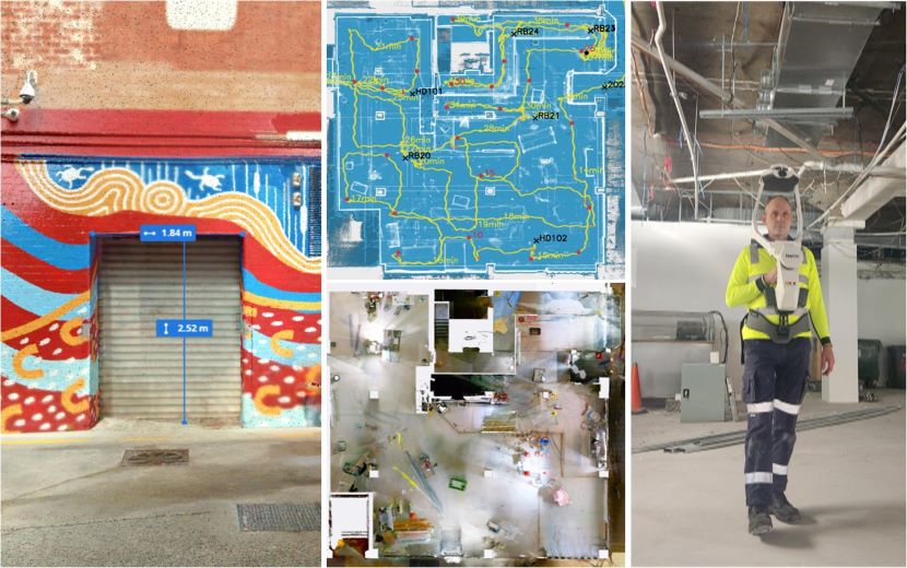
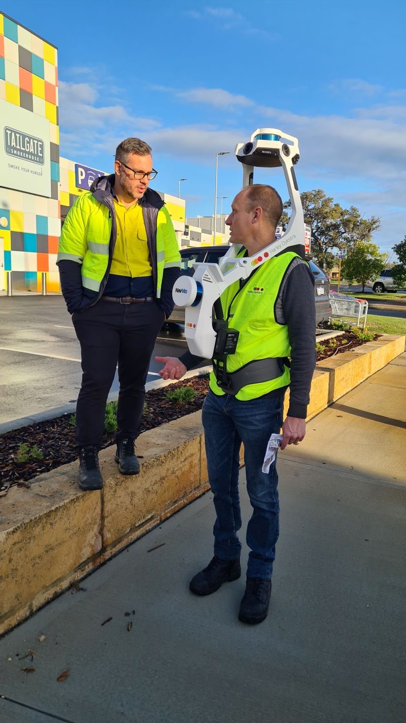
Russell Bergsma, Harley Dykstra’s Mobile Mapping and Reality Capture Technician, has been excited since the day the VLX landed in his metropolitan office. Russell says “as a wearable mobile mapping device, requiring no tripod setup or target placement, the VLX is fast and flexible. We have used the VLX in high-traffic areas or where traffic management would not be feasible and in hard-to-access areas that could not be captured with traditional methods. I am also privileged to be surrounded by a team of experienced surveyors, which integrates beautifully with the VLX’s capability to capture survey control. It’s a great feature to be able to precisely geo-register and align datasets in local or national coordinate systems.”
Real field applications
Harley Dykstra has recently mapped several older historical properties where there were no existing drawings on record. Our architects clients were tasked with commencing concept design for a significant renovation project but needed as-built data. Our scanning technician walked both inside and outside of the property, returned to the office, and processed the data that evening. We were able to share the online data via a secure link with the architect the following day.
Harley Dykstra has found the VLX to be a flexible instrument that has allowed us to capture data in different environments and different contexts.
On another project, Harley Dykstra captured 500 m of road including pathways, line markings, traffic islands, driveway crossovers, and building facades. The road had some traffic flowing past throughout the day and yet no traffic management was required. With the software’s capacity to remove moving traffic from the point cloud, the data set was clean and unimpeded. Harley Dykstra was able to capture the roadway and surrounds with survey control resulting in a greater accuracy.
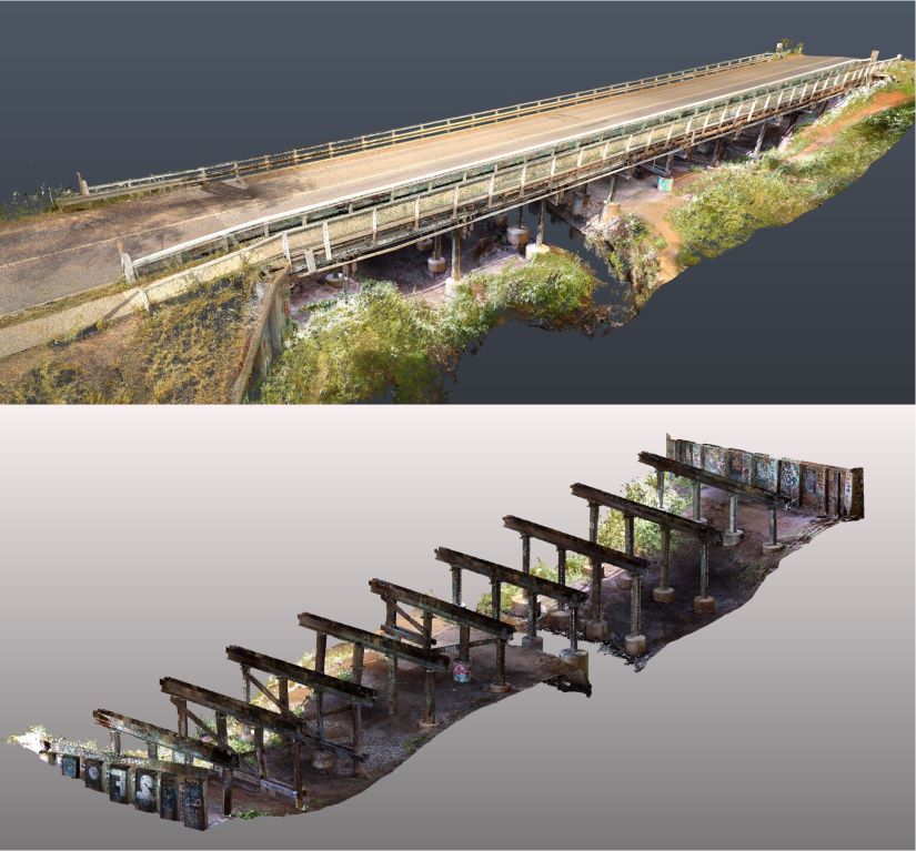
Another example where the VLX saved time and resources involved scanning a bridge. “I asked our survey team how long it would have taken them with a Terrestrial Laser Scanner (TLS), and they estimated two days of data capture as you would have to move the scanner multiple times around the pylons and so on. It took me just 45 minutes to walk all areas of the bridge and capture a fully detailed point cloud with the VLX,” Russell said.
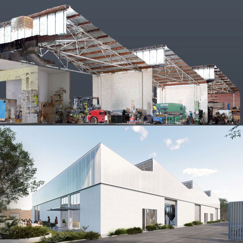
More recently Harley Dykstra teamed up with an architectural firm and worked together on an exciting industrial renovation and re-use project. The NavVis VLX mobile mapping scanner captured the interior and exterior of an existing warehouse, with survey control to provide the scan data in real-world coordinates.
The architects provided some valuable feedback:
“We found the viewing software easy to navigate and were able to easily take it into Revit which helped identify some substantial differences between the building and our CAD model.”
“The detail of the scan was incredible, almost too much. It required some discipline on our end when CAD modelling to only include the elements we really required.”
“We can see us using this service again for other projects where an as-built capture is warranted.”
As seen through our adoption of other technology including drones and remotely piloted watercraft, Harley Dykstra is always looking for ways to be inventive and innovative. With the VLX we are pushing the boundaries in a wide variety of applications. Russell explains that through this approach, the company believes it can help further advance in technology and software.
Online processing and viewing platform:
While it is hard not to be impressed with the site capture of the NavVis, the processing and sharing functions of the software have proved very user-friendly.
“We have found the workflow easy to follow and relatively quick, our clients have been impressed with how fast we have been able to scan a site and provide them a link to the registered data,” Russell said. “This has also meant that from a price point, we have a service that is affordable, and more reliable than old drawings as it is truly an as-built capture.”
According to Russell, the data quality is so good that it almost negates the need for clients to visit the site in person. “As the data is available online anywhere, anytime, clients see little need for a site visit. They can measure, add notes, and comments to the point cloud data making it a valued tool for their design team.”
In an industry that demands collaboration and communication, the NavVis VLX fosters a seamless information-sharing process. The point cloud data acquired can be digitised into 2D drawings, 3D models, and even immersive 3D virtual site visits. This means that stakeholders, clients, and team members can visualise the project’s progress and nuances with unprecedented clarity. With so much quality data available from one source, everyone is inherently on the same page and contributing to making well-informed decisions.
So where to from here?
Harley Dykstra’s integration of the NavVis VLX mobile mapping and reality capture scanner marks a new era for planning and surveying. By harnessing the power of cutting-edge technology, they are accelerating workflows, and redefining collaboration.
“The challenge ahead is one of awareness, value, and assisting our clients in using point cloud data effectively, Companies that embrace change and who are forwarding thinking when it comes to new technologies, will be the real winners” Russell said.
In our meetings with new and existing clients over the past six months it has not been unusual to hear sentences like, ‘this would have been so good to have had on such and such a project,’ or ‘wow, you even managed to capture that feature while scanning’.
When it comes to taking point clouds into third-party software and using the geolocation functionality of the data, there is still some education required. Thankfully at Harley Dykstra, we have staff with a wealth of experience in interacting with point cloud data and we are happy to assist our clients where needed.
As the survey and planning industry evolves, these innovations serve as a testament to Harley Dykstra’s commitment to excellence, innovation, and driving their projects into the future walking alongside their clients with confidence.
