Bathymetric surveying, commonly known as hydro surveying, stands as a testament to the relentless march of technological innovation in the field of land surveying. This specialised technique, once limited by the constraints of manual measurements and cumbersome equipment, has undergone a remarkable transformation, thanks to advancements in technology. Today, hydro surveyors (like Harley Dykstra) harness the power of cutting-edge tools such as hydrones to unlock the secrets hidden beneath the surface of bodies of water, revolutionising how we map and understand aquatic environments.
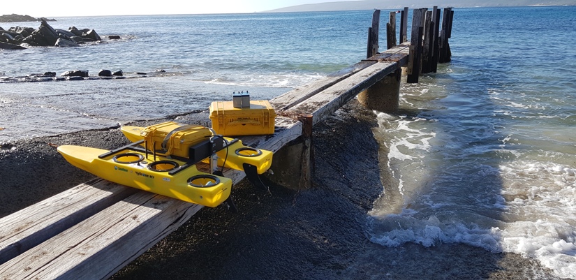
HYDRONES
At the heart of hydro surveying lies the utilisation of hydrones, also known as unmanned underwater vehicles (UUVs), which are equipped with sophisticated sensors and imaging systems. These remotely operated vehicles can navigate the depths with precision, capturing high-resolution data of underwater terrain and features. Coupled with GPS technology and sonar systems, hydrones provide an unparalleled level of accuracy and efficiency in bathymetric mapping, enabling surveyors to create detailed underwater topographic maps and 3D models.
TAILINGS DAM DURVEYS
One of the most critical applications of bathymetric surveying is in tailings dam surveys. Tailings dams, used to store waste materials from mining operations, require meticulous monitoring to assess their structural integrity and mitigate environmental risks. Hydro surveying plays a pivotal role in conducting comprehensive inspections of these dams, enabling early detection of potential hazards such as seepage, erosion, or subsidence. By providing detailed insights into the underwater topography and sedimentation levels, hydro surveying helps ensure the safety and sustainability of mining operations.
PRACTICAL APPLICATIONS
Hydro surveying is not limited to specific types of water bodies but finds extensive applications across various aquatic environments. Whether it’s inland lakes, rivers, coastal waters, or offshore sites, hydro surveying can be employed to map and monitor a wide range of water bodies. From shallow coastal areas to deep oceanic trenches, hydrones are capable of navigating diverse underwater landscapes, making bathymetric surveying a versatile tool for marine exploration and resource management.
In the realm of civil engineering, hydro surveying finds numerous applications in infrastructure projects such as harbour development, dredging operations, and underwater pipeline installations. By providing accurate data on water depths, seabed conditions, and underwater obstacles, hydro surveying helps engineers make informed decisions during the planning, design, and construction phases of marine projects. From optimising navigation routes to ensuring the stability of offshore structures, bathymetric surveying plays a crucial role in enhancing safety, efficiency, and sustainability in maritime operations.
In conclusion, bathymetric surveying represents a remarkable fusion of technology, expertise, and innovation, enabling us to unravel the mysteries of the underwater world. With its wide-ranging applications and transformative capabilities, hydro surveying continues to redefine our understanding of aquatic environments and shape the future of marine exploration and resource management.
If you’d like to know more about our Bathymetric surveying services here at Harley Dykstra, get in touch.